Carlton County Residents Asked to Preserve the County Road 4 Organic Corridor. So Why Does the 2050 Plan Target the Corridor for Development?
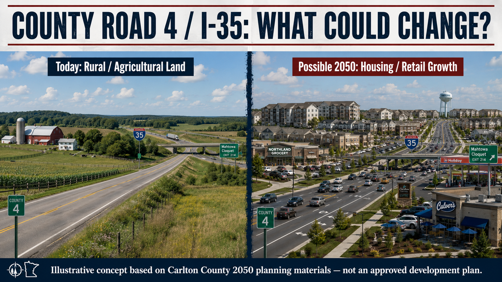
Carlton County residents were asked what they wanted their community to look like in 2050. Among the answers recorded in the County's own planning documents was an unusually specific request: preserve the “County Road 4 organic corridor.” Yet months later, the preliminary future-land-use plan presented to County officials identified County Road 4 as a corridor for Regional Commercial development while nearby Mahtowa was identified for higher-density Mixed-Use growth. That does not mean development has been approved or that anyone's farm has been rezoned. But it raises a fundamental public question that Carlton County residents deserve to have answered: How did a documented request to preserve this rural agricultural corridor become a planning framework that could ultimately encourage a dramatically different future for it?
by Carlton County Watch
Carlton County officials have repeatedly emphasized that the County's proposed 2050 Comprehensive Plan remains a work in progress and that its preliminary land-use map reflects ideas and recommendations gathered during public engagement.
The County's own newly available planning records, however, raise an important question:
What did the public actually ask for — and how were those comments translated into the preliminary future land-use map presented to the Carlton County Board of Commissioners and Planning Commission on August 5?
That question is particularly significant for the rural County Road 4 corridor near Mahtowa and Interstate 35.
Because buried within the County's own Community Visioning Workshop Summary is a remarkably specific statement.
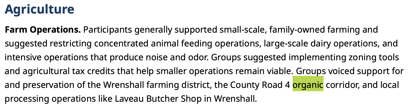
Participants called for the preservation of the “County Road 4 organic corridor.”
How did the County get from one to the other?
What Residents Said About County Road 4
Carlton County and its planning consultant, Houseal Lavigne, conducted a series of public-engagement events as part of the 2050 Comprehensive Plan process.
One of those meetings was an open-to-all Community Visioning Workshop held April 8, 2026, at the Barnum Event Center. Fifty-one people participated.
According to Houseal Lavigne's official summary, agriculture was an important component of the discussion.
Participants “generally supported small-scale, family-owned farming.” They discussed zoning tools and agricultural tax credits designed to help smaller farming operations remain economically viable.
And then the report becomes geographically specific.
According to the County's own document:
“Groups voiced support for and preservation of the Wrenshall farming district, the County Road 4 organic corridor, and local processing operations like Laveau Butcher Shop in Wrenshall.”
That was not the only expression of support for agricultural preservation.
At the April 7 Regional County Stakeholders Visioning Workshop, participants expressed a desire to preserve agricultural land, particularly in eastern Carlton County. One group suggested financial incentives encouraging landowners to move property from A-2 Agriculture/Rural Residential zoning back to the more restrictive A-1 Agriculture/Forest Management classification in order to increase the County's agricultural land base.
The “big ideas” coming from that workshop included:
“Preserve rural character — zoning A-2 back to A-1.”
Participants also called upon the County to support agricultural growers, processors, transportation and retail.
The message wasn't anti-development.
It was considerably more nuanced.
Residents wanted housing. They wanted jobs. They wanted businesses. They wanted economic development.
But they also repeatedly asked the County to protect rural character, agricultural land, small farms and local food production.
And at least one part of that message was extraordinarily specific:
Preserve the County Road 4 organic corridor.
Then Came the Preliminary Land-Use Plan
On August 5, 2026, the Carlton County Board of Commissioners and Planning Commission held a special joint meeting to review a draft Vision Statement, Goals and Preliminary Land Use Plan prepared by Houseal Lavigne.
The document was dated July 7, 2026 and labeled “DRAFT FOR INTERNAL REVIEW.”
It emphasized that the proposal was preliminary and subject to change.
That distinction matters.
The map presented August 5 was not an enacted zoning ordinance, and property shown under a future designation was not automatically rezoned by the meeting.
But the map was also more consequential than an informal brainstorming exercise.
Houseal Lavigne explained that parcels had been assigned one of ten future land-use designations and stated:
“They form the basis for development review and approval and will help guide future zoning amendments needed to implement the Plan's recommendations.”
In other words, the map is preliminary.
But it is intended to influence future land-use decisions.
And that brings us back to County Road 4.
What Does “Regional Commercial” Mean?
The preliminary plan defines Regional Commercial development as auto-oriented development characterized by larger retailers, national restaurant chains, gas stations and hotels.
Houseal Lavigne then identifies where those types of development should be directed:
“These uses are currently concentrated and should continue to be on engaging interchange nodes such as Exit 235 by Black Bear Casino and along transportation corridors like I-35; MN 210; and County Roads 4, 6, and 8 to leverage the County's position as a hub for tourism.”
County Road 4 was therefore not merely drawn onto a map accidentally.
It is named in the written narrative.
And that creates a question the County should answer publicly:
How did public input favoring preservation of the County Road 4 organic corridor become a preliminary planning document specifically identifying County Road 4 for Regional Commercial development?
There may be an explanation.
Perhaps other residents identified the interchange for development.
Perhaps Map.Social submissions favored commercial development there.
Perhaps Houseal Lavigne independently concluded that the interchange was appropriate for future development.
Perhaps County staff recommended the designation.
Perhaps several of those factors contributed.
But the public deserves to know.
There Was Support for I-35 Development
Fair reporting requires acknowledging another part of the record.
Some workshop participants did support increased development around Interstate 35.
At the April 7 invite-only Regional County Stakeholders workshop, multiple groups identified I-35, MN 210 and MN 73 as opportunities for commercial development.
Importantly, however, the written summary described properties “adjacent to I-35 near cities and other commuter routes” as particularly well-positioned for commercial development.
Participants also said the County should focus on highway exits in an effort to retain visitors who currently drive through Carlton County without stopping.
That provides evidence supporting some additional I-35 development.
It does not, however, resolve the County Road 4 question.
General support for better utilization of Interstate 35 does not necessarily equal public support for transforming every rural interchange along Interstate 35.
And it certainly does not erase the County's own documentation that residents specifically asked to preserve the County Road 4 organic corridor.
Mahtowa Was Also Identified for Higher-Density Mixed Use
There is another aspect of the preliminary plan that deserves careful attention.
The same July 7 document specifically identifies Mahtowa as an area targeted for a future Mixed-Use designation.
Houseal Lavigne describes Mixed-Use areas as accommodating both commercial and residential uses within the same building or development site and says these areas typically feature “higher density development relative to surrounding rural areas.”
The report then says:
“Under County jurisdiction, this designation is targeted toward unincorporated rural centers with Atkinson and Mahtowa … and strategic crossroads along major County corridors.”
That language does not establish that Carlton County has approved a housing development at Mahtowa.
It does not establish that the County intends to acquire privately owned farmland.
But it does establish something important:
The County's preliminary planning framework contemplates greater development intensity at Mahtowa than exists in the surrounding rural countryside today.
The Housing Question
That becomes particularly interesting when the preliminary land-use plan is read alongside Carlton County's other planning documents.
Carlton County's 2024 housing analysis estimated demand between 2023 and 2028 for approximately 240 to 300 new for-sale homes and 375 to 460 rental units, together with additional senior housing.
The study identifies limited subdivision-ready land as one barrier to producing that housing.
The 2050 planning memorandum says the future land-use plan will accommodate small-lot single-family homes, duplexes and fourplexes, townhomes, mixed-use developments with apartments, multifamily housing and senior housing.
County department heads went even further during the December 2025 project kickoff.
Their recommended actions included:
identifying areas for moderate- to high-density housing;
supporting residential development to attract new residents and satisfy employer needs;
identifying project-ready development sites;
building infrastructure to support long-term growth; and
expanding commercial and industrial zoning.
At the May 20 public workshop, housing along the I-35 corridor was also specifically identified.
And the July preliminary plan itself explains why Interstate 35 matters to housing.
Houseal Lavigne writes that I-35 acts as a “magnet for growth” and says interstate access has contributed to increased residential-development interest and housing demand, particularly where residents can conveniently commute to the Duluth-Superior area.
That raises another legitimate question:
Is the 2050 Plan laying the groundwork for significantly more residential as well as commercial development around Carlton County's rural I-35 interchanges?
The documents do not yet provide the answer.
But they provide ample reason to ask the question.
Agriculture or Development?
The County's preliminary vision contains both promises.
One goal is to:
“Preserve agricultural lands, support local farmers, and encourage agri-tourism ventures that promote sustainable farming practices and local food systems.”
Another seeks commercial corridors and investment.
Another calls for a wide variety of new housing.
Another calls for infrastructure capable of supporting future development.
Those goals do not inherently conflict.
Carlton County can grow while preserving agriculture.
It can develop interstate commercial nodes while protecting family farms.
It can build housing without converting every convenient rural parcel into development land.
But accomplishing those objectives requires choices.
And those choices become particularly important when a rural agricultural corridor sits immediately beside Interstate 35.
The Maps Tell the Story
Carlton County's own maps provide perhaps the clearest illustration of what is at stake.
The Existing Conditions Memorandum describes rural lands as the predominant land use in Carlton County and says those lands include working farms, livestock farms and large-lot residential development that comprise a vital part of the County's economy and character.
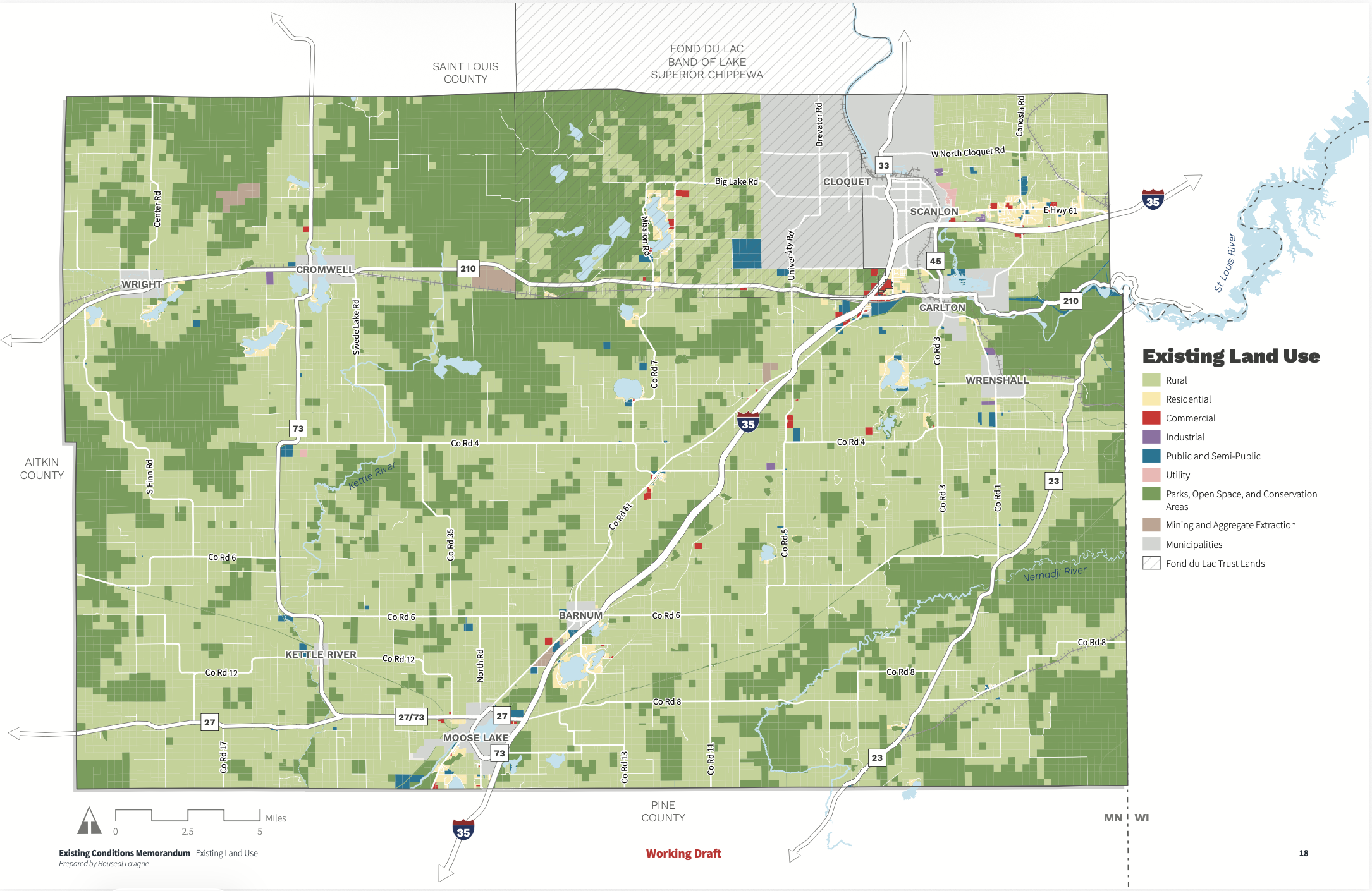
The County's current zoning map largely reflects the agricultural and rural nature of the countryside surrounding its developed communities.
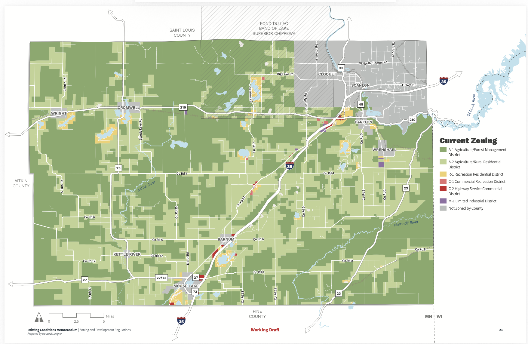
The preliminary 2050 map looks forward.
Around the County Road 4/I-35/Mahtowa area, the County is now contemplating land-use categories capable of accommodating substantially different forms and intensities of future development.
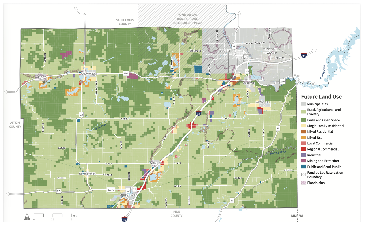
Again, the preliminary map does not order development to occur.
But comprehensive plans matter precisely because they establish the policy framework under which later zoning, infrastructure and development decisions are made.
That is why residents should be paying attention now — not after a rezoning application or development proposal arrives.
Let the Documents Speak for Themselves
Carlton County Watch's earlier reporting on the 2050 preliminary land-use proposal drew criticism and assertions that the implications of the plan had been overstated. The additional planning records now publicly available allow residents to evaluate that debate for themselves. Rather than asking readers to accept anyone's characterization of the proposal — including ours — we encourage them to examine the County's own workshop summaries, existing zoning maps, preliminary future-land-use maps and planning documents.
Show the Public the Chain of Decision-Making
There is a simple way Carlton County can resolve these questions.
Show residents how the preliminary map was created.
Identify the public comments, workshop maps, surveys, Map.Social submissions, consultant recommendations, staff discussions and advisory-committee decisions that resulted in the County Road 4 and Mahtowa designations.
If residents asked for Regional Commercial development at the County Road 4 interchange, show the comments.
If Houseal Lavigne independently recommended it, explain why.
If County staff proposed it, identify the planning analysis supporting that decision.
And if the designation resulted from balancing competing public comments, explain how those competing comments were weighed.
That is not opposition to planning.
That is planning conducted in public.
One Sentence Deserves an Answer
Out of hundreds of pages produced during the Carlton County 2050 planning process, one sentence now stands out:
Residents asked for preservation of the “County Road 4 organic corridor.”
A few months later, the County's preliminary future-land-use document specifically identified County Road 4 for Regional Commercial development while identifying nearby Mahtowa for higher-density Mixed-Use development.
Those two facts can coexist.
But the County owes its residents the missing part of the story:
How did we get from one to the other?
Carlton County Watch will continue following the 2050 Comprehensive Plan as that answer — and the future of County Road 4 and Carlton County — takes shape.