From Family Farms to “Regional Commercial”? Carlton County’s 2050 Plan Raises Questions in Mahtowa
A preliminary County land-use map identifies the I-35/County Road 4 interchange for regional-scale commercial development — an area now characterized by longstanding farms and rural properties.
by Carlton County Watch
For generations, the countryside surrounding Interstate 35 and County Road 4 near Mahtowa has been associated with farms, open land, barns and the rural landscape that helps define southern Carlton County.
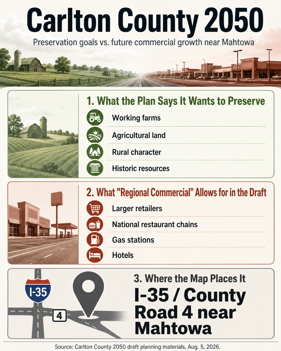
Under a preliminary land-use map now being considered as part of the Carlton County 2050 Comprehensive Plan, however, part of that landscape could have a very different future.
On August 5, 2026, the Carlton County Board of Commissioners met jointly with the Carlton County Planning Commission at the County Transportation Building. Representatives of Houseal Lavigne, the consulting firm working with Carlton County on its new Comprehensive Land Use Plan, presented a draft vision statement, goals and a Preliminary Land Use Plan intended to guide development in Carlton County over approximately the next two decades.
The meeting materials include a countywide Future Land Use map.
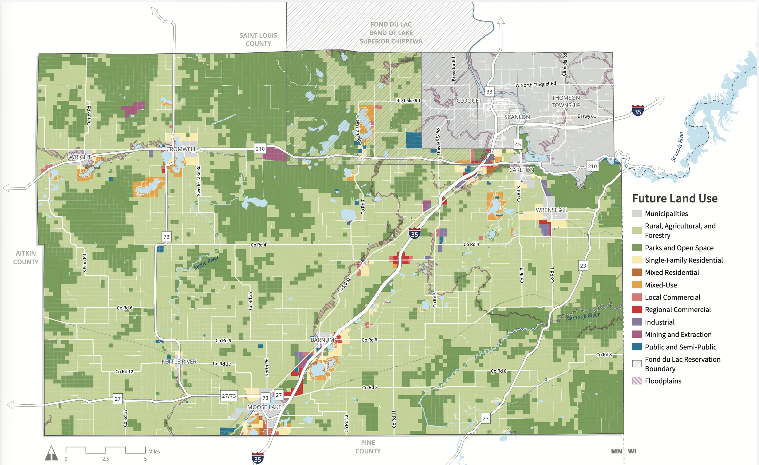
Proposed Future Land Use — County Commissioners approved the agenda, Houseal Lavigne then presented the Draft Vision Statement, Goals, and Preliminary Land Use Plan. August 5, 2026. Source: Carlton County
And one portion of that map is drawing particular attention in Mahtowa.
A Red Block at I-35 and County Road 4
On the preliminary map appearing on page 11 of the August 5 agenda packet, land immediately surrounding the I-35 and County Road 4 interchange is shown in bright red.
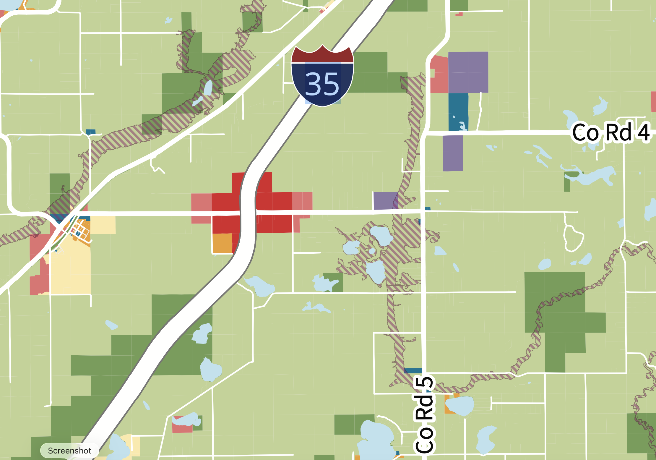
According to the map legend, red represents “Regional Commercial.”
That designation is significant because the planning memorandum defines Regional Commercial development quite differently from the small businesses traditionally associated with Carlton County's rural communities.
Under the draft plan, Regional Commercial areas are intended for automobile-oriented development such as larger retailers, national restaurant chains, gas stations and hotels serving residents as well as interstate travelers.
The plan specifically identifies major transportation corridors including I-35 and County Road 4 as locations where regional commercial development should be concentrated.
For property owners surrounding the Mahtowa interchange, the designation raises an obvious question:
Why here?
Property owners have told Carlton County Watch that much of the affected area consists of longstanding family farms, some operated by families for generations and containing older farmhouses, barns and other structures associated with the area's agricultural history.
Nothing in the August 5 materials suggests those properties are presently being condemned, acquired or ordered converted to commercial use.
But that does not make the map meaningless.
Quite the opposite.
This Is Not Rezoning — But It Could Help Shape Future Rezoning
There is an important distinction residents should understand.
The map presented August 5 is a preliminary future land-use map. It does not, by itself, rezone anyone's property.
In fact, the consultant repeatedly labels the materials as a draft and states that the documents will continue to be adjusted and refined as the planning process moves forward.
The rough-draft minutes from the August 5 meeting also do not reflect formal adoption of the Comprehensive Plan. They show a motion approving the meeting agenda, presentation of the draft plan by Houseal Lavigne, and a subsequent motion to adjourn.
That distinction is important.
But so is another sentence buried in the planning memorandum.
Houseal Lavigne explains that the ten future land-use designations will form a basis for future development review and approval and will help guide future zoning amendments necessary to implement the Comprehensive Plan.
Minnesota law similarly provides that once a county comprehensive plan is adopted by ordinance, that plan serves as the basis for the County's official land-use controls.
In other words:
The red color on today's planning map is not a bulldozer permit. But neither is it merely decorative.
It represents a public policy decision about what County planners believe a particular area should become over the coming decades.
And that makes the question of how those decisions are being made extremely important to the people who already live, work and farm there.
A Conflict Within the County's Own Vision?
Perhaps the most interesting aspect of the proposal is that the County's draft plan repeatedly emphasizes preservation of precisely the type of landscape surrounding Mahtowa.
The draft vision anticipates a future Carlton County in which farmland continues alongside forests, parks and lakes and describes balanced growth that preserves the County's heritage and identity.
Under Agriculture, one of the County's stated goals is to preserve agricultural lands, support farmers and promote sustainable farming and local food systems.
Under Land Use and Development, the County proposes protecting rural character and the natural environment.
The plan's Rural, Agricultural and Forestry designation goes even further, characterizing rural land as the “backbone” of Carlton County's landscape and emphasizing preservation of working lands, agricultural heritage and rural character.
Those are admirable objectives.
But they raise an unavoidable planning question when viewed alongside the Mahtowa map:
How does Carlton County decide which farms are part of the agricultural heritage it intends to preserve — and which farms are potential locations for hotels, gas stations, national restaurants and larger-scale commercial development?
That is a question the final Comprehensive Plan should answer clearly.
The Interstate Is Driving the Discussion
The County's consultants make no secret of I-35's importance.
The memorandum describes Interstate 35 as a powerful force shaping development in Carlton County, attracting commercial and industrial development around high-traffic interchanges.
The document also identifies a perceived problem: thousands of motorists travel through Carlton County without stopping at local businesses. The planning strategy therefore contemplates turning some highway interchanges into destinations capable of attracting travelers off the interstate and into the County's economy.
From an economic-development perspective, the reasoning is understandable.
Land at an interstate interchange is valuable precisely because it offers visibility, traffic and convenient access.
But economic opportunity is only one side of land-use planning.
The other side involves the people who already own the land.
Questions Carlton County Should Answer
Before the preliminary map advances toward a final Comprehensive Plan, Carlton County Watch believes several questions deserve straightforward answers:
Who specifically selected the land surrounding I-35 and County Road 4 for the Regional Commercial designation, and what criteria were used?
Which parcels — and how many acres — are presently included within the proposed Regional Commercial area?
What are those parcels currently zoned?
Were affected landowners individually informed that their properties were being considered for a Regional Commercial future-land-use designation?
What public comments or economic studies support placing a regional commercial node at this particular interchange?
Does the County anticipate future rezoning of these properties after adoption of the 2050 Comprehensive Plan?
What water, wastewater, transportation or utility infrastructure would be required to accommodate the scale of commercial development contemplated by the designation?
How would the County reconcile commercial development with its stated goals of preserving working farms, rural character and historic or cultural resources?
Can property owners request that their parcels be removed from or reconsidered within the Regional Commercial designation before the plan is finalized?
Those questions are not arguments against economic development.
They are questions about where development occurs, who bears its consequences, and how much voice existing property owners receive before a long-range government planning document identifies their land for a substantially different future use.
The Time to Ask Is Now
There may never be a better time for Mahtowa-area landowners to become involved.
The August 5 document expressly states that the Preliminary Land Use Plan remains in draft form and will be adjusted and refined as the planning process continues.
Minnesota law also requires public-hearing procedures before a county comprehensive plan is ultimately adopted by ordinance.
That means the story of the I-35/County Road 4 interchange has not necessarily been written.
But the first draft has.
And on Carlton County's preliminary 2050 map, a portion of rural Mahtowa that today contains farms and open countryside has been colored red for Regional Commercial development.
For the families whose names may have been attached to that ground for a century or more, that small patch of red deserves a much larger public conversation.